- Home <
- Business review <
- Mineral resources and mineral reserves <
- South Africa <
- Far West
Far West
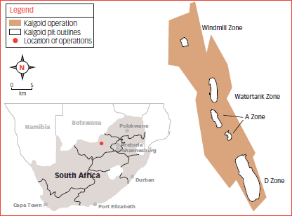
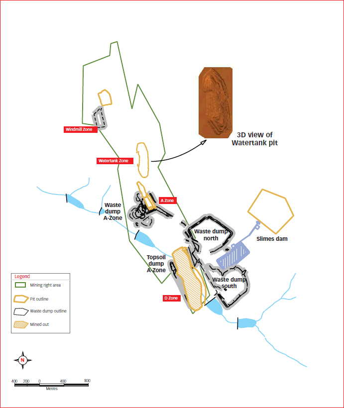
Kalgold
Geology
The Kalgold operation is located within the Kraaipan Greenstone Belt, 60 kilometres south of Mafikeng. This belt is part of the larger Amalia- Kraaipan Greenstone terrain, consisting of north trending linear belts of Archaean meta-volcanic and metasedimentary rocks, separated by granitoid units. Mineralisation occurs in shallow dipping quartz veins, which occur in clusters or swarms, within the steeply dipping magnetitechert banded iron formation. Disseminated sulphide mineralisation, dominated mostly by pyrite, occurs around and between the shallow dipping quartz vein swarms. The D Zone, the largest orebody encountered here, has been extensively mined within a single open-pit operation, along a strike length of 1 300 metres. Mineralisation has also been found in the Mielie Field Zone (adjacent to the D Zone), the A Zone and A Zone West (along strike to the north of the D Zone), and the Watertank and Windmill areas to the north of the A Zone.
Gold – Mineral resources
| Measured | Indicated | Inferred | Total | |||||||||||||
|---|---|---|---|---|---|---|---|---|---|---|---|---|---|---|---|---|
| Operations | Tonnes (Mt) | g/t | Gold (000 kg) | Gold (000 oz) | Tonnes (Mt) | g/t | Gold (000 kg) | Gold (000 oz) | Tonnes (Mt) | g/t | Gold (000 kg) | Gold (000 oz) | Tonnes (Mt) | g/t | Gold (000 kg) | Gold (000 oz) |
| Underground | ||||||||||||||||
| Kalgold | 34.0 | 0.86 | 29 | 944 | 63.8 | 0.94 | 60 | 1 922 | 27.2 | 0.93 | 25 | 818 | 125.0 | 0.92 | 115 | 3 684 |
| Grand total | 34.0 | 0.86 | 29 | 944 | 63.8 | 0.94 | 60 | 1 922 | 27.2 | 0.93 | 25 | 818 | 125.0 | 0.92 | 115 | 3 684 |
Modifying factors
| Operations | MCF (%) | Dilution (%) | PRF (%) |
|---|---|---|---|
| Kalgold | 100 | 2 | 85 |
- MCF = Mine call factor
- PRF = Plant recovery factor
Gold – Mineral reserves
| Proved | Probable | Total | ||||||||||
|---|---|---|---|---|---|---|---|---|---|---|---|---|
| Operations | Tonnes (Mt) | g/t | Gold (000 kg) | Gold (000 oz) | Tonnes (Mt) | g/t | Gold (000 kg) | Gold (000 oz) | Tonnes (Mt) | g/t | Gold (000 kg) | Gold (000 oz) |
| Kalgold | 21.9 | 0.82 | 18 | 575 | 7.5 | 1.07 | 8 | 258 | 29.4 | 0.88 | 26 | 833 |
| Grand total | 21.9 | 0.82 | 18 | 575 | 7.5 | 1.07 | 8 | 258 | 29.4 | 0.88 | 26 | 833 |
Kalgold operations
Kimberley reef
HARMONY ANNUAL REPORT 2010