- Home <
- Business review <
- Mineral resources and mineral reserves <
- South Africa <
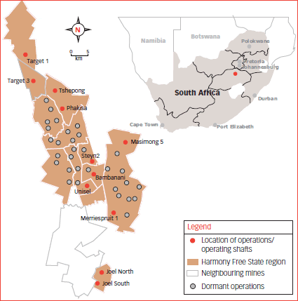
- Free State operations
Free State operations
Geology
Harmony’s Free State operations are located on the south-western corner of the Witwatersrand Basin, between the towns of Allanridge, Welkom, Theunissen and Virginia. The basin, situated on the Kaapvaal Craton, has been filled by a 6-kilometre thick succession of sedimentary rocks, which extends laterally for hundreds of kilometres.
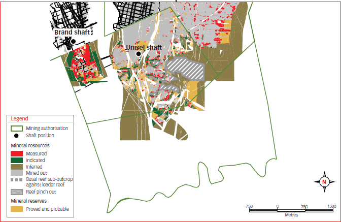
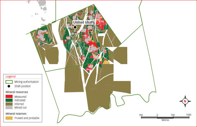
The Free State goldfield is divided into two sections, cut by the north-south striking De Bron Fault. This major structure has a vertical displacement of about 1 500 metres in the region of Bambanani, as well as a lateral shift of 4 kilometres. This lateral shift can allow a reconstruction of the orebodies of Unisel to the west of the De Bron Fault and Merriespruit to the east. A number of other major faults (Stuirmanspan, Dagbreek, Arrarat and Eureka) lie parallel to the De Bron Fault.
To the west of the De Bron fault, the mines and shafts currently in operation are Target, Tshepong, Phakisa, Nyala, Unisel, Bambanani and Joel. Dips are mostly towards the east, averaging 30 degrees but become steeper as they approach the De Bron Fault. To the east of the fault lie Merriespruit 1 and Masimong. These mostly dip towards the west at 20 degrees, although Masimong is structurally complex and dips of up to 40 degrees have been measured. Between these two blocks lies the uplifted horst block of West Rand Group sediments with no reef preserved.
The western margin area is bound by synclines and reverse thrust faults and is structurally complex. Towards the south and east, reefs sub-crop against overlying strata, eventually cutting out against the Karoo to the east of the lease area.
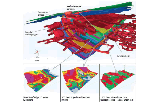
Most of the mineral resource tends to be concentrated in reef bands located on one or two distinct unconformities. A smaller portion of the mineral resource is located on other unconformities. Mining that has taken place is mostly deep-level underground mining, exploiting the narrow, generally shallow dipping tabular reefs.
The Basal Reef is the most common reef horizon and is mined at all shafts except Target and Joel. It varies from a single pebble lag to channels of more than 2 metres thick. It is commonly overlain by shale, which thickens northwards. Tshepong has resorted to undercutting of its mining panels to reduce the effect of shale dilution.
The second major reef is the Leader Reef, located 15-20 metres above the Basal Reef. This is mined mostly at shafts to the south – Unisel and Merriespruit 1. Further north, it becomes poorly developed with erratic grades. The reef consists of multiple conglomerate units, separated by thin quartzitic zones, often up to 4 metres thick. A selected mining cut on the most economic horizon is often undertaken.
The B Reef is a highly channelised orebody located 140 metres stratigraphically above the Basal Reef. Because of its erratic nature, it is only mined at Masimong and Tshepong. Within the channels, grades are excellent, but this reduces to nothing outside of the channels. Consequently, both shafts have undertaken extensive exploration to locate these pay channels.
The A Reef is also a highly channelised reef, located some 40 metres above the B Reef. This is currently only mined at Harmony 2 and Brand, although an extensive channel lies along the western margin from Nyala to Lorraine. It consists of multiple conglomerate bands of up to 4 metres thick and a selected mining cut is usually required to optimise the orebody.
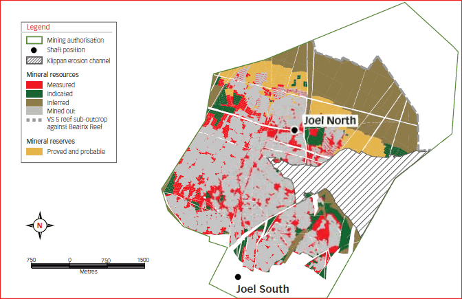
Joel Mine, located 30 kilometres south of Welkom, is the only Harmony Free State operation to mine the Beatrix Reef. This varies from a single-pebble lag to a multiple conglomerate, often showing mixing of the reef with some of the overlying lower grade VS5 (mixed pebble conglomerate) material. None of the other reefs are present this far south, having sub-cropped against the Beatrix Reef.
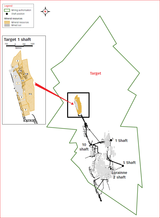
The Target operations are located at the northern extent of the Free State goldfields, some 20 kilometres north of Welkom. The reefs currently exploited are the Elsburg-Dreyerskuil conglomerates, which form a wedge-shaped stacked package, comprising 35 separate reef horizons, often separated by quartzite beds. The Elsburg Reefs are truncated by an unconformity surface at the base of the overlying Dreyerskuil Member. Below the sub-crop, the Elsburg dips steeply to the east, with dips becoming progressively shallower down dip. Close to the sub-outcrop, the thickness of the intervening quartzites reduces, resulting in the Elsburg Reefs coalescing to form composite reef packages that are exploited by massive mining techniques at the Target mine. The Dreyerskuil also consists of stacked reefs dipping shallowly to the east. These reefs tend to be less numerous, but more laterally extensive than the underlying Elsburg Reefs.
Gold - Mineral resources
| Measured | Indicated | Inferred | Total | |||||||||||||
|---|---|---|---|---|---|---|---|---|---|---|---|---|---|---|---|---|
| Operations | Tonnes (Mt) | g/t | Gold (000 kg) | Gold oz (000) | Tonnes (Mt) | g/t | Gold (000 kg) | Gold oz (000) | Tonnes (Mt) | g/t | Gold (000 kg) | Gold oz (000) | Tonnes (Mt) | g/t | Gold (000 kg) | Gold oz (000) |
| Underground | ||||||||||||||||
| Bambanani | ||||||||||||||||
| Bambanani | 11.7 | 11.47 | 134 | 4 318 | 3.2 | 9.75 | 31 | 1 009 | 1.0 | 10.67 | 11 | 356 | 15.9 | 11.07 | 176 | 5 683 |
| Steyn 2 | 3.2 | 11.49 | 37 | 1 190 | 0.7 | 12.04 | 8 | 272 | 0.9 | 10.01 | 9 | 284 | 4.8 | 11.30 | 54 | 1 746 |
| Total | 14.9 | 11.47 | 171 | 5 508 | 3.9 | 10.16 | 39 | 1 281 | 1.9 | 10.37 | 20 | 640 | 20.7 | 11.12 | 230 | 7 429 |
| Joel | 5.0 | 6.85 | 34 | 1 096 | 5.5 | 7.27 | 40 | 1 276 | 12.5 | 6.06 | 76 | 2 439 | 23.0 | 6.52 | 149 | 4 811 |
| Masimong 5 | 11.1 | 7.68 | 85 | 2 732 | 6.0 | 7.09 | 43 | 1 371 | 79.7 | 5.89 | 469 | 15 073 | 96.8 | 6.17 | 597 | 19 176 |
| Phakisa | 4.6 | 7.06 | 33 | 1 052 | 25.7 | 10.90 | 279 | 8 986 | 60.7 | 6.69 | 407 | 13 074 | 91.0 | 7.90 | 719 | 23 112 |
| Target | ||||||||||||||||
| Target 1 | 5.4 | 10.11 | 55 | 1 770 | 14.4 | 7.37 | 106 | 3 411 | 5.1 | 6.32 | 32 | 1 038 | 24.9 | 7.75 | 193 | 6 219 |
| Target 3 | 7.1 | 9.83 | 70 | 2 240 | 10.1 | 8.67 | 88 | 2 827 | 5.5 | 6.85 | 38 | 1 210 | 22.7 | 8.59 | 196 | 6 277 |
| Total | 12.5 | 9.95 | 125 | 4 010 | 24.5 | 7.91 | 194 | 6 238 | 10.6 | 6.59 | 70 | 2 248 | 47.6 | 8.15 | 389 | 12 496 |
| Tshepong | 12.8 | 11.00 | 141 | 4 527 | 12.5 | 10.90 | 136 | 4 371 | 11.3 | 9.55 | 108 | 3 473 | 36.6 | 10.52 | 385 | 12 371 |
| Virginia | ||||||||||||||||
| Merriespruit 1 | 8.1 | 5.47 | 44 | 1 417 | 3.3 | 4.21 | 14 | 444 | 35.4 | 3.88 | 137 | 4 410 | 46.8 | 4.18 | 195 | 6 271 |
| Unisel | 9.8 | 5.82 | 57 | 1 828 | 9.4 | 5.29 | 50 | 1 604 | 17.3 | 5.39 | 93 | 3 001 | 36.5 | 5.48 | 200 | 6 433 |
| Total | 17.9 | 5.66 | 101 | 3 245 | 12.7 | 5.01 | 64 | 2 048 | 52.7 | 4.37 | 230 | 7 411 | 83.3 | 4.75 | 395 | 12 704 |
| Total Free State | ||||||||||||||||
| Underground | 78.8 | 8.75 | 690 | 22 170 | 90.8 | 8.76 | 795 | 25 571 | 229.4 | 6.01 | 1 380 | 44 358 | 399.0 | 7.18 | 2 864 | 92 099 |
| Surface | ||||||||||||||||
| Free State Surface | ||||||||||||||||
| Phoenix | – | – | – | – | 92.4 | 0.30 | 28 | 899 | 1.2 | 0.22 | 0 | 9 | 93.6 | 0.30 | 28 | 908 |
| St Helena | – | – | – | – | 288.5 | 0.25 | 72 | 2 319 | – | – | – | – | 288.5 | 0.25 | 72 | 2 319 |
| Waste rock dumps | – | – | – | – | 9.0 | 0.56 | 5 | 162 | 22.0 | 0.49 | 11 | 345 | 31.0 | 0.51 | 16 | 507 |
| Slimes dams | – | – | – | – | 582.0 | 0.22 | 129 | 4 135 | 183.6 | 0.21 | 38 | 1 220 | 768.6 | 0.22 | 167 | 5 355 |
| Total Free State Surface | – | – | – | – | 971.9 | 0.24 | 234 | 7 515 | 206.8 | 0.24 | 49 | 1 574 | 1 178.7 | 0.24 | 283 | 9 089 |
| Grand total | 78.8 | – | 690 | 22 170 | 1 062.7 | – | 1 029 | 33 086 | 436.2 | – | 1 429 | 45 932 | 1 577.7 | – | 3 147 | 101 188 |
Uranium - Mineral resources
| Measured | Indicated | Inferred | Total | |||||||||||||
|---|---|---|---|---|---|---|---|---|---|---|---|---|---|---|---|---|
| Operations | Tonnes (Mt) | kg/t | U3O8 (Mkg) | U3O8 (Mlb) | Tonnes (Mt) | kg/t | U3O8 (Mkg) | U3O8 (Mlb) | Tonnes (Mt) | kg/t | U3O8 (Mkg) | U3O8 (Mlb) | Tonnes (Mt) | kg/t | U3O8 (Mkg) | U3O8 (Mlb) |
| Underground | ||||||||||||||||
| Masimong 5 | 9.7 | 0.28 | 3 | 6 | 10.7 | 0.28 | 3 | 7 | 76.7 | 0.24 | 18 | 40 | 97.1 | 0.25 | 24 | 53 |
| Phakisa | 0.5 | 0.16 | 0 | 0 | 22.2 | 0.20 | 4 | 10 | 12.7 | 0.20 | 2 | 5 | 35.4 | 0.20 | 6 | 15 |
| Tshepong | 0.3 | 0.21 | 0 | 0 | 3.5 | 0.20 | 1 | 2 | 33.3 | 0.16 | 5 | 12 | 37.1 | 0.16 | 6 | 14 |
| Total Free State | ||||||||||||||||
| Underground | 10.5 | 0.28 | 3 | 6 | 36.4 | 0.22 | 8 | 19 | 122.7 | 0.21 | 25 | 57 | 169.6 | 0.22 | 36 | 82 |
| Surface | 0.0 | 0.00 | – | 0 | 159.9 | 0.11 | 17 | 38 | 13.5 | 0.34 | 5 | 10 | 173.4 | 0.12 | 22 | 48 |
| Total Free State | ||||||||||||||||
| Surface | 0.0 | 0.00 | – | 0 | 159.9 | 0.11 | 17 | 38 | 13.5 | 0.34 | 5 | 10 | 173.4 | 0.12 | 22 | 48 |
| Grand total | 10.5 | 0.28 | 3 | 6 | 196.3 | 0.13 | 25 | 56 | 136.2 | 0.22 | 30 | 67 | 343 | 0.17 | 58 | 130 |
Modifying factors
| Operations | MCF (%) | SW (cm) | MW (cm) | PRF (%) |
|---|---|---|---|---|
| Bambanani | 82 | 187 | 206 | 96 |
| Steyn 2 | 81 | 142 | 173 | 96 |
| Joel | 88 | 150 | 176 | 95 |
| Masimong 5 | 68 | 135 | 156 | 96 |
| Phakisa | 82 | 106 | 127 | 96 |
| Target 3 | 76 | 100 | 119 | 96 |
| Tshepong | 66 | 105 | 130 | 96 |
| Merriespruit 1 | 68 | 173 | 214 | 94 |
| Unisel | 76 | 186 | 203 | 95 |
| Operations | MCF (%) | PRF (%) |
|---|---|---|
| Target 1 | 100 | 96 |
| Free State (Phoenix) | 100 | 55 |
| Free State (St Helena) | 100 | 55 |
| Free State (Other) | 100 | 55 |
- MCF = Mine call factor
- MW = Milling width
- SW = Stoping width
- PRF = Plant recovery factor
Gold - Mineral reserves
| Proved | Probable | Total | ||||||||||
|---|---|---|---|---|---|---|---|---|---|---|---|---|
| Operations | Tonnes (Mt) | (g/t) | Gold (000 kg) | Gold (000 oz) | Tonnes (Mt) | (g/t) | Gold (000 kg) | Gold (000 oz) | Tonnes (Mt) | (g/t) | Gold (000 kg) | Gold (000 oz) |
| Underground | ||||||||||||
| Bambanani | ||||||||||||
| Bambanani | 3.9 | 10.41 | 40 | 1 301 | – | – | – | – | 3.9 | 10.41 | 40 | 1 301 |
| Steyn 2 | 0.5 | 7.26 | 3 | 105 | 0.1 | 6.95 | 1 | 25 | 0.6 | 7.20 | 4 | 130 |
| Total | 4.4 | 10.08 | 43 | 1 406 | 0.1 | 6.95 | 1 | 25 | 4.5 | 10.00 | 44 | 1 431 |
| Joel | 1.2 | 6.25 | 7 | 240 | 1.5 | 5.61 | 8 | 264 | 2.7 | 5.90 | 15 | 504 |
| Masimong 5 | 5.4 | 5.11 | 28 | 894 | 1.9 | 5.09 | 10 | 306 | 7.3 | 5.10 | 38 | 1 200 |
| Phakisa | 0.6 | 4.65 | 3 | 94 | 19.4 | 8.13 | 158 | 5 065 | 20.0 | 8.02 | 161 | 5 159 |
| Target | ||||||||||||
| Target 1 | 4.0 | 5.50 | 22 | 702 | 7.6 | 4.49 | 34 | 1 104 | 11.6 | 4.84 | 56 | 1 806 |
| Target 3 | 1.0 | 7.59 | 8 | 252 | 3.6 | 6.33 | 23 | 743 | 4.6 | 6.61 | 31 | 995 |
| Total | 5.0 | 5.93 | 30 | 954 | 11.2 | 5.08 | 57 | 1 847 | 16.2 | 5.34 | 87 | 2 801 |
| Tshepong | 13.1 | 5.33 | 70 | 2 247 | 9.4 | 5.36 | 51 | 1 626 | 22.5 | 5.34 | 121 | 3 873 |
| Virginia | ||||||||||||
| Merriespruit 1 | 0.4 | 4.01 | 2 | 58 | 0.1 | 3.55 | 0 | 9 | 0.5 | 3.94 | 2 | 67 |
| Unisel | 2.3 | 4.71 | 11 | 349 | 1.4 | 4.67 | 7 | 214 | 3.7 | 4.70 | 18 | 563 |
| Total | 2.7 | 4.60 | 13 | 407 | 1.5 | 4.62 | 7 | 223 | 4.2 | 4.60 | 20 | 630 |
| Total Free State Underground | 32.4 | 5.98 | 194 | 6 242 | 45 | 6.46 | 292 | 9 356 | 77.4 | 6.26 | 486 | 15 598 |
| Surface | ||||||||||||
| Free State Surface | ||||||||||||
| Phoenix | – | – | – | – | 92.4 | 0.30 | 28 | 899 | 92.4 | 0.30 | 28 | 899 |
| St Helena | – | – | – | – | 288.5 | 0.25 | 72 | 2 319 | 288.5 | 0.25 | 72 | 2 319 |
| Waste rock dumps | – | – | – | – | 5.1 | 0.61 | 3 | 99 | 5.1 | 0.61 | 3 | 99 |
| Slimes dams | – | – | – | 540.5 | 0.22 | 121 | 3 895 | 540.5 | 0.22 | 121 | 3 895 | |
| Total Free State | ||||||||||||
| Surface | – | – | – | – | 926.5 | 0.24 | 224 | 7 212 | 926.5 | 0.24 | 224 | 7 212 |
| Grand total | 32.4 | – | 194 | 6 242 | 971.5 | – | 516 | 16 568 | 1 003.90 | – | 710 | 22 810 |
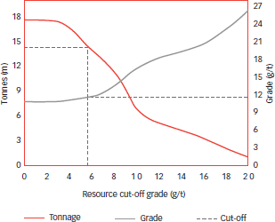
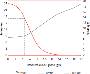
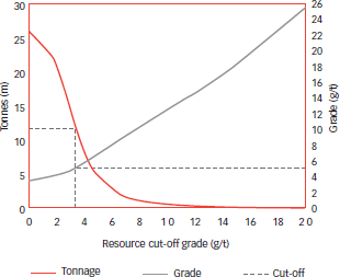
Bambanani: Grade tonnage curve (excl Steyn 2)
(measured and indicated resources)
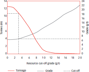
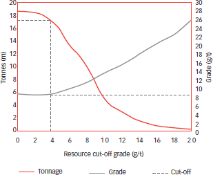
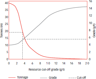
Joel: Grade tonnage curve
(measured and indicated resources)
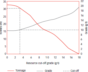
Masimong: Grade tonnage curve
(measured and indicated resources)
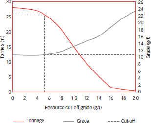
Phakisa: Grade tonnage curve
(measured and indicated resources)
Target: Grade tonnage curve (excl Target 3)
(measured and indicated resources)
Tshepong: Grade tonnage curve
(measured and indicated resources)
Merriespruit: Grade tonnage curve
(measured and indicated resources)
Unisel: Grade tonnage curve
(measured and indicated resources)
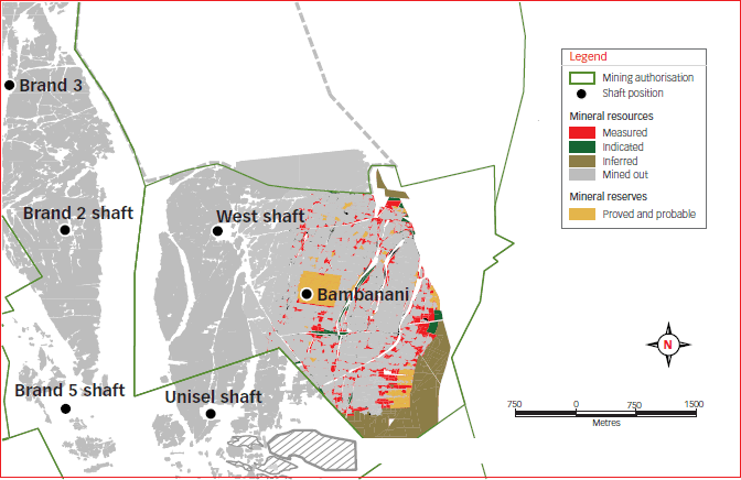
Bambanani – Basal reef
Joel mine – Beatrix reef
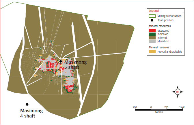
Masimong mine – Basal reef
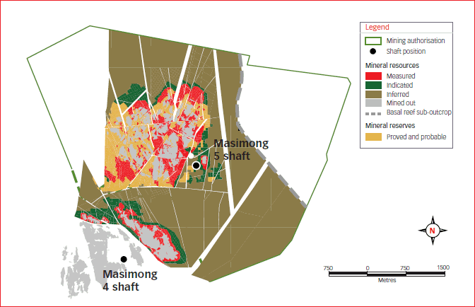
Masimong mine – B reef
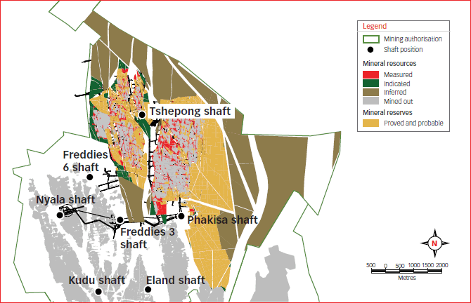
Phakisa mine, Tshepong mine – Basal reef
Target mine – Elsburg and Dreyerskuil reefs
Target mine
Unisel – Basal reef
Unisel – Leader reef
HARMONY ANNUAL REPORT 2010