- Home <
- Business review <
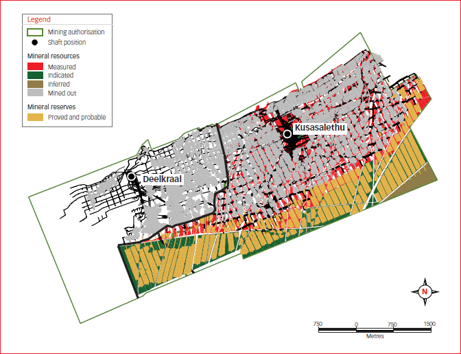
- Mineral resources and mineral reserves <
- South Africa <
- West Rand
West Rand
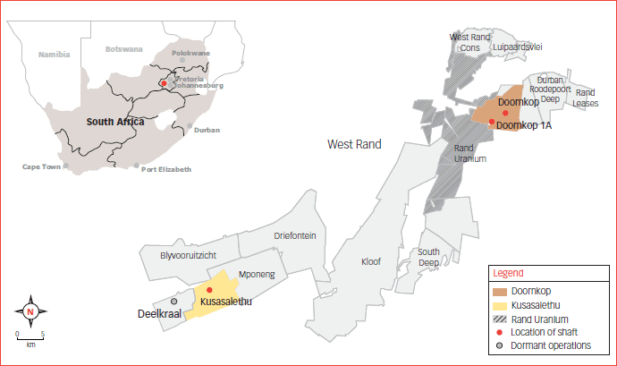
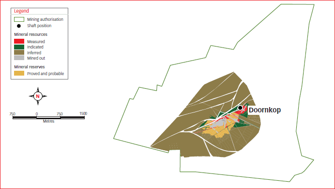
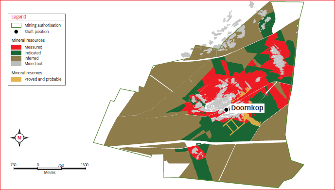
Doornkop
Geology
The structure of the West Rand goldfield is dominated by the Witpoortjie and Panvlakte Horst blocks, which are superimposed over broad folding associated with the south-east plunging West Rand syncline. At the Doornkop mine, both the Kimberley Reef and the South Reef are exploited.
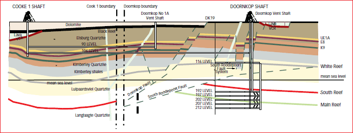
The Doornkop shaft lease area is bounded by and lies to the south-east of the major north-easterly striking Roodepoort Fault, which dips to the south and constitutes the southern edge of the Witpoortjie Horst Block or Gap. This Horst Block is comprised of the stratigraphically older sediments of the West Rand Group, the overlying Central Rand Group sediments having been removed by erosion. A number of other faults, forming part of and lying south-east of the Roodepoort Fault, including the Saxon Fault, also constitute conspicuous structural breaks. A second major fault, the Doornkop Fault, which trends in an east-west direction occurs towards the southern portion of the lease area. This fault dips to the south and has an up-throw to the north.
Nearly the entire upper Witwatersrand section is present in the Doornkop lease area and therefore all the major zones are present, though, due to the distance of the area from the fan head, the number of economic bands and their payability is limited. Eight of the well-known reefs are present in the area, but only the Kimberley Reef and South Reef are considered viable at this stage.
The resource is concentrated in the Kimberley and South Reefs. The Kimberley Reef is contained in the Vlakfontein member of the Westonaria Formation. This reef, also known as the K9 Reef horizon, rests on an unconformity and is a complex multi-pulse conglomerate, which can be separated into four facies or cycles. All four cycles consist on average of an upper conglomerate and a lower quartzite. The characteristics of every cycle are area-dependent and the grades are variable within each cycle.
The South Reef is approximately 900 metres below the current Kimberley Reef mining area, and between 7.5 and 60 metres above the Main Reef horizon. The hanging wall to the South Reef consists of siliceous quartzites with non-persistent bands of ’blueshot‘ grit and thin argillite partings. The footwall to the South Reef is a light coloured and fairly siliceous quartzite. Secondary conglomerate bands and stringers in the hanging wall and footwall of the South Reef may contain sporadic gold values.
The general strike of the reef is east-west, with a dip from 10 to 20 degrees. The orebody at Doornkop has a strike length of 4 kilometres and a width of 4 kilometres from west to east.
Kusasalethu
Geology
The structure of the orebody on the Far West Rand is dominated by a series of east-trending normal faults with throws of up to 40 metres, as well as a series of north-north-east striking normal faults with generally smaller displacements in the north-west. Faulting is generally less prevalent than in other Witwatersrand Basin goldfields. The primary reefs exploited are the Ventersdorp Contact Reef (VCR) and the Carbon Leader, which are 900 to 1 300 metres apart, increasing from east to west. Secondary targets are the Middelvlei Reef (50 to 75 metres above the Carbon Leader) and the Mondeor Conglomerate Reef Zone, which sub-crops beneath the VCR at Deelkraal and on the western side of Kusasalethu.
Doornkop
Gold – Mineral resources
| Measured | Indicated | Inferred | Total | |||||||||||||
|---|---|---|---|---|---|---|---|---|---|---|---|---|---|---|---|---|
| Operations | Tonnes (Mt) | g/t | Gold (000 kg) | Gold (000 oz) | Tonnes (Mt) | g/t | Gold (000 kg) | Gold (000 oz) | Tonnes (Mt) | g/t | Gold (000 kg) | Gold (000 oz) | Tonnes (Mt) | g/t | Gold (000 kg) | Gold (000 oz) |
| Underground | ||||||||||||||||
| Doornkop | ||||||||||||||||
| Kimberley Reef | 31.8 | 2.22 | 71 | 2 269 | 50.4 | 1.86 | 93 | 3 006 | 177.9 | 1.81 | 321 | 10 335 | 260.1 | 1.87 | 486 | 15 610 |
| South Reef | 1.0 | 7.08 | 7 | 229 | 1.9 | 6.42 | 12 | 398 | 20.0 | 8.35 | 167 | 5 366 | 22.9 | 8.13 | 186 | 5 993 |
| Grand total | 32.8 | 2.37 | 78 | 2 498 | 52.3 | 2.01 | 105 | 3 404 | 197.9 | 2.47 | 488 | 15 701 | 283.0 | 2.37 | 672 | 21 603 |
Modifying factors
| Operations | MCF (%) | SW (cm) | MW (cm) | PRF (%) |
|---|---|---|---|---|
| Doornkop | ||||
| Kimberley Reef | 95 | 434 | 434 | 95 |
| South Reef | 75 | 124 | 151 | 95 |
- MCF = Mine call factor
- MW = Milling width
- SW = Stoping width
- PRF = Plant recovery factor
Gold – Mineral reserves
| Proved | Probable | Total | ||||||||||
|---|---|---|---|---|---|---|---|---|---|---|---|---|
| Operations | Tonnes (Mt) | g/t | Gold (000 kg) | Gold (000 oz) | Tonnes (Mt) | g/t | Gold (000 kg) | Gold (000 oz) | Tonnes (Mt) | g/t | Gold (000 kg) | Gold (000 oz) |
| Underground | ||||||||||||
| Doornkop | ||||||||||||
| Kimberley Reef | 0.9 | 1.79 | 2 | 53 | 1.0 | 2.16 | 2 | 68 | 1.9 | 1.98 | 4 | 121 |
| South Reef | 0.7 | 5.06 | 3 | 107 | 1.5 | 4.41 | 7 | 209 | 2.1 | 4.61 | 10 | 316 |
| Grand total | 1.6 | 3.13 | 5 | 160 | 2.5 | 3.6 | 9 | 277 | 4.0 | 3.5 | 14 | 437 |
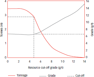
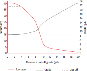
Doornkop South Reef: Grade tonnage curve
(measured and indicated resources)
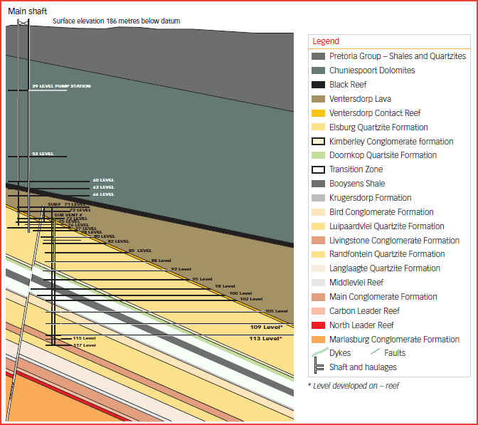
Cooke 1/Doornkop geological section looking west
Not to scale
Doornkop mine – South reef
Doornkop mine – Kimberley reef
Kusasalethu
Gold – Mineral resources
| Measured | Indicated | Inferred | Total | |||||||||||||
|---|---|---|---|---|---|---|---|---|---|---|---|---|---|---|---|---|
| Operations | Tonnes (Mt) | g/t | Gold (000 kg) | Gold (000 oz) | Tonnes (Mt) | g/t | Gold (000 kg) | Gold (000 oz) | Tonnes (Mt) | g/t | Gold (000 kg) | Gold (000 oz) | Tonnes (Mt) | g/t | Gold (000 kg) | Gold (000 oz) |
| Underground | ||||||||||||||||
| Kusasalethu | 13.0 | 9.46 | 123 | 3 957 | 24.8 | 8.97 | 223 | 7 169 | 1.5 | 9.35 | 14 | 440 | 39.3 | 9.15 | 360 | 11 566 |
| Grand total | 13.0 | 9.46 | 123 | 3 957 | 24.8 | 8.97 | 223 | 7 169 | 1.5 | 9.35 | 14 | 440 | 39.3 | 9.15 | 360 | 11 566 |
Modifying factors
| Operations | MCF (%) |
SW (cm) | MW (cm) | PRF (%) |
|---|---|---|---|---|
| Kusasalethu | 87 | 129 | 158 | 96 |
- MCF = Mine call factor
- MW = Milling width
- SW = Stoping width
- PRF = Plant recovery factor
Gold – Mineral reserves
| Proved | Probable | Total | ||||||||||
|---|---|---|---|---|---|---|---|---|---|---|---|---|
| Operations | Tonnes (Mt) | g/t | Gold (000 kg) | Gold (000 oz) | Tonnes (Mt) | g/t | Gold (000 kg) | Gold (000 oz) | Tonnes (Mt) | g/t | Gold (000 kg) | Gold (000 oz) |
| Underground | ||||||||||||
| Kusasalethu | 12.4 | 6.70 | 83 | 2 680 | 23.4 | 6.42 | 150 | 4 834 | 35.9 | 6.51 | 234 | 7 514 |
| Grand total | 12.4 | 6.70 | 83 | 2 680 | 23.4 | 6.42 | 150 | 4 834 | 35.9 | 6.51 | 234 | 7 514 |
Kusasalethu – Section through main shaft and sub-shaft looking east – Not to scale
Kusasalethu: Grade tonnage curve
(measured and indicated resources)
Kusasalethu
Ventersdorp Contact Reef (VCR)
HARMONY ANNUAL REPORT 2010